Sloes, Scones and Stones

It was a bright but cloudy Friday morning when I set off from the East Dart Hotel in Dartmoor, and tempted as I was to stay another day and explore the moors a bit more, I had plans for other things, and so I decided to get going. My original plan was to drive to Tinatgel and explore the castle ruins on that day, but as it happened, I got distracted by other, equally fascinating things.

First of all, I headed south towards Plymouth with one destination in mind: the Black Friar’s Distillery, makers of Plymouth Gin. I have toured plenty of wineries, breweries and whiskey distilleries in my travels, but never a gin distillery, and although it was a slight detour, I wanted to go and have a look.

thumbnail_IMG_5589

I’m pleased to say it was definitely worth the side trip. The building, with its very seaside-looking white façade, is tucked in between market shops and cobbled streets in an area called The Barbican, close to the harbour. Quaint though it is, there wasn’t much in the way of parking and by the time I found a space and made my way back to the shop, I had just missed the start of the tour. That was no trouble though, as the very friendly staff member ushered me through a series of locked doors and onto the back of the tour, and told me, very trustingly, that I could pay afterwards. Isn’t it just nice when that sort of thing happens?

The tour turned out to be quite fascinating, although the poor girl giving it had to talk at about 500 miles an hour to cover it all in 40 minutes. I kept expecting her to blow a tire. But anyway, from her I learned that the building has existed since 1431, and was first used as a monastery, hence the name Black Friar’s. The monastery was closed after the disillusion of the monasteries and it was converted to a distillery in 1793. After this very speedy and condensed history lesson we were escorted into the distillery room which has so much alcohol vapours wafting around that we had to turn off our phones and touch an earthing bar on the way in. Inside were three enormous copper vats, two of which are used for making gin, and a third, which no one has any idea what it’s for or how it came to be there, a fact which I found highly amusing. They don’t know how long it’s been there either, as most of their offices, along with all their documentation, were bombed during the war – fortunately they missed the distillery itself. It’s possible that it was brought in to make vodka during the war, but as they have no records, they can’t be sure. They can’t get rid of it either, as it would cost too much. So if there’s anyone out there who wants an enormous Victorian copper vat, and is willing to go and collect it, it’s yours for the taking – or so we were told!

From there we were given a lesson in botanicals and smelling dried things in small jars, all good fun, especially as we had some gin to sample with it. There were lots of other facts and figures all imparted at top speed and most of which I’ve since forgotten, but here’s an interesting fact I did retain – Plymouth Gin have been suppliers of gin for the Royal Navy almost since they opened, but rather than the regular 41% gin, they get the special Navy Strength Gin which is 57% – a significant difference. Apparently this is because once upon a time, barrels of gin were stored on the same level as the cannons, and the lower strength gin would ruin the gunpowder if it spilled. But at 57% – apparently – the alcohol content is high enough that the gunpowder will still light, even if it is doused in spirit.

IMG_3731

We finished the tour with a gin and tonic in the Refectory bar, which has a very stunning, partially restored wooden beam ceiling. By the time I finished I was feeling quite relaxed, not exactly in a hurry but keen to get on with my sight-seeing. I drove out of Plymouth, across the Tamar bridge and into Cornwall.

I was heading in the direction of Tintagel but there were a few things I wanted to check out along the way – the first was a small stone structure which I found in one of my guidebooks, which turned out to be another gem well worth the detour. Dupath Well Chapel is a small chapel built over a spring, although apparently it’s quite a large example of its kind. It’s in the middle of a farm, in a small fenced-in field now run by English Heritage. I had to park outside a barn and walk down a short driveway to get to it, feeling like I was intruding on someone’s back yard, but eventually I walked around a corner and there it was, stunning and peaceful, completely out of place and yet eerily separate from the modern life that’s sprung up around it.

IMG_3740

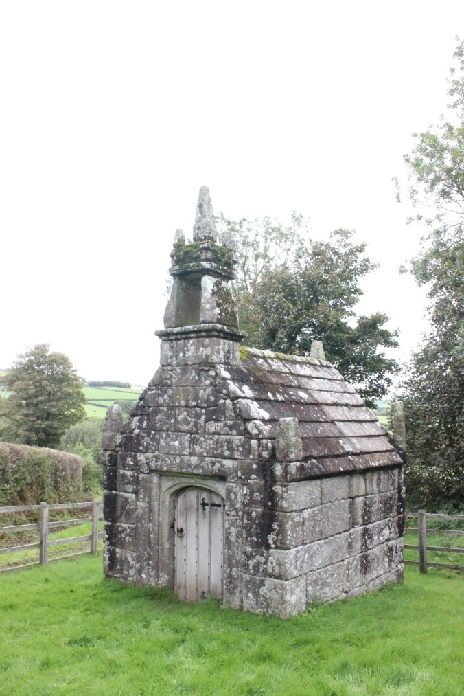
The spring, which has probably been a place of worship since celtic times, is apparently the site of a famous duel between two Saxons, Colan and Gottlieb, who fought over a woman and both subsequently died – or so the legend goes. The current building is thought to have been built by some local Augustinaian monks in around 1510. It’s a simple structure of Cornish granite, with a pretty canopy and bell tower above the door, and I found it utterly charming. I wandered around it, then wandered in and sat down for a while. I leaned against the cool stone feeling as though I could have sat there for hours, as the sunlight slanted in through the narrow windows and the water trickled in merrily – but I had more places to go, so I got up and set off again, feeling grateful that there are still such evocative and untouched places in the world.

IMG_3764

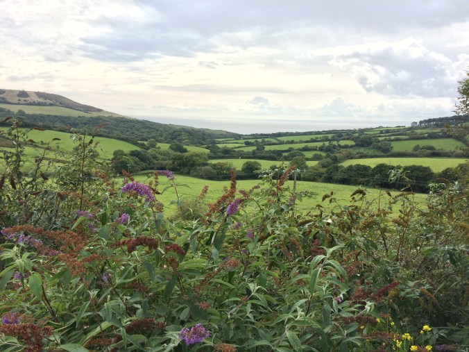
My next destination was Bodmin Moor, but I took another stop on the way to enjoy an essential local delicacy – a Cornish cream tea! Because of my detours the day before, I missed out on one in Devon, but I was determined not to miss out in Cornwall! I found a café up on top of a hill and sat enjoying my scones, taking care to do it the Cornish way – jam first, then cream!! I had given up my plan of making it to Tintagel that day, so as I sat there,  looking out over green fields, criss-crossed with their darker green hedges, I felt as though I had all the time in the world – and the rain drizzling down steadily didn’t dampen my spirits at all.

thumbnail_IMG_5593

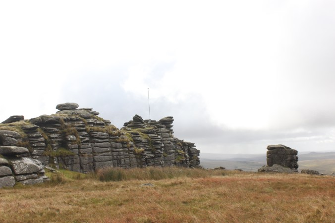
From there I drove to the Village of Minions on Bodmin Moor. The highest village in Cornwall, almost all of it was built within a twenty-year period between 1863 and 1880 to service the local mines, quarries and railway. From its centre you can still see the pump houses and other buildings dotted around the surrounding hills and fields, all in various states of disrepair. These were not what I had come for, however – I was looking for the Hurlers – in other words, another pile of ancient rocks.

I found a car park which had a lot of fields and walking trails leading off it, but couldn’t find any kind of signpost, map or notice anywhere, so I employed my trusty method of heading in the same direction as other people. I wandered around for a while over the pretty but soggy moor before I found them, and what a sight they are. The Hurlers, one of the largest prehistoric sights in Britain, are a series of three stone circles linked by a 2-metre-wide pathway on a large, flat bit of the moor. According to local legend, some men were out on the moor on a Sunday playing an ancient game called hurling. As a punishment for playing on the Sabbath they were all turned into stone where they stood.

IMG_3797

It’s hard to describe, after the fact, just how mysterious and amazing these stones are. Archaeologists date them to around 1500BC, and believe they were originally all cut to the same size and shape, with a quartzite crystal floor in the central circle. Most of the stones are still there, though some are now much smaller and most of them lean drunkenly one way or the other. There’s no trace of the floor, but from the middle you can see a clear trail of upright stones leading off in one direction and reaching up to the Cheesewring – another gravity-defying stone formation – in the other.

As I approached them and wandered into the first circle, the rain stopped and the sun made a rare appearance, giving them a mysterious and colourful glow. Once again I marveled at the industriousness of our bronze age ancestors, and felt a kind of awe at the faith they must have had in whatever it was they believed in. I wondered what kinds of rites and rituals could have been performed here, what occasions and ceremonies had these stones stood witness to?

IMG_3800

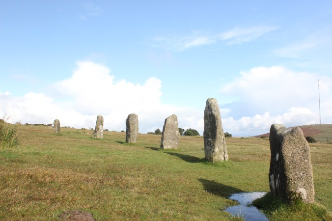
Like the stone rows and formations at Dartmoor, the Hurlers aren’t restricted in any way. They’re just there, standing silently on the moor, for anyone to approach, touch, appreciate. I walked around them for a little while, then squelched back to the car feeling quite satisfied. The Hurlers, I decided, where well worth getting soggy feet for.

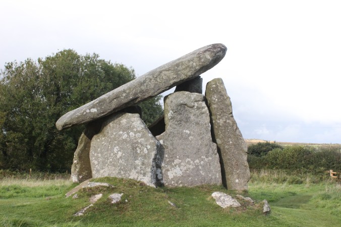
There was just one more stop I wanted to make that day – although I was very tempted to drive towards a village called ‘Harrow Barrow’, purely out of curiosity – and that was to yet another ancient monument:  Trethevy Quoit in the village of Darite. It took me about ten minutes to drive there, and I pulled up in a tiny layby on the top of a very narrow and windy road, with no clue as to anything remarkable being nearby except a small brown sign with the English Heritage logo and an arrow on it. I followed the sign across the road and through a kissing gate, stepped up into a field and there it was – one of the largest Neolithic burial chambers in the country.

IMG_3825

Like the other monuments I’d been looking at, it was not restricted in any way – it was just there, standing at least twice as tall as me, with its large side stones and even larger capstone, which sat at a jaunty angle and gave it the appearance of an oversized outhouse. Originally, most of it would have been buried by a mound of earth, but that has disappeared leaving it mostly exposed. Right next to it is a row of houses, and several of the locals passed by with their dogs, taking no more notice of it than if it were a peculiarly shaped tree. It really was quite remarkable.

IMG_3829

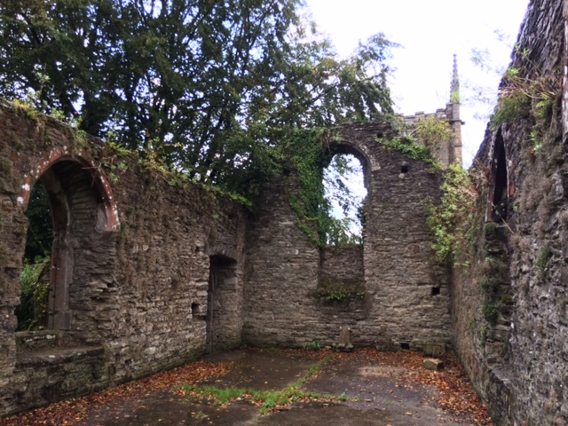
I stayed that night in a small pub in the village of Bodmin, which unfortunately didn’t serve meals, so the girl who showed me to my room sent me to a nearby pub called the Weavers. It was drizzling again, but not cold, so on the way I took a detour around the local church where I discovered yet another ruin, this time most of the walls and floor of an old chapel. The evening light reflecting off the wet stone made it pleasingly atmospheric, and once again I felt a deep gratitude for ancient builders and unexpected discoveries.

IMG_5615

My dinner that night was disappointing, but well supplemented by the local lager, Korev (the Cornish word for beer), and I enjoyed the company of a lively boxer called Dixie, who was in a much more sociable mood than her owners. Although I missed the company of the East Dart Hotel, I couldn’t help feeling, as I hopped into bed later, that it had been a full and satisfying day. And although I hadn’t made it to the place I’d originally been aiming for, where I had been had definitely been worth the side trips. And I was definitely going to Tintagel tomorrow.

Dartmoor Rocks

After a lovely drive down to Devon and a fun, chatty evening in the pub, I woke up feeling optimistic and excited about having a whole day to drive around and explore Dartmoor. After a pot of tea and full English breakfast in the company of my friends from the previous night, I felt ready for just about anything. Our hostess and breakfast cooker extraordinaire, Rosie, turned out to be just as chatty as the rest of us and was full of stories about how many people had crashed their cars either avoiding or not noticing sheep on the road, including one about a young man who was following his father’s 4wd, but was enjoying the view so much that he didn’t notice that the 4wd had stopped and crashed into the back of it. Now there’s a call to the insurance company I wouldn’t want to make.

I soon realised that if I stayed to listen to all her stories I would be there all day, so I extricated myself as politely as I could and headed off. My first plan was to go looking for some particular stone formations which I knew were somewhere on the moors, fortunately not far from where I was, so I set off in the direction of a village called Merrivale. As it turns out, there are quite a lot of stone formations scattered around the moors, and from the road it’s impossible to know which one is the one you’re looking for. I reached the village, which meant I had gone too far, turned around and drove back past all the stone formations again. There were many small car parking areas just off the road, so in the end I picked one which looked more likely than the others, based purely on the fact that it had a tourist coach in it. I crossed the road and found a path leading up a hill towards some stones on the top, and without any better plan, I decided to follow it.

IMG_3519

From the bottom of the path, I guessed it would take me about 15 minutes to get to the top. About half an hour later, when I was finally starting to feel I was almost there, I had to concede that looks, and distances, can be deceiving. But when I finally did get to the top, what I found was really quite remarkable. Several stone structures, most of which I hadn’t been able to see from the bottom, jutted out of the hill as if they had been pulled up from the ground with a giant pair of tweezers. Some formed perfect squares, others appeared to be stacked on top of each other precariously, as if one touch from my finger would send them toppling down the hill. The stones were darker than the surrounding earth, as if deliberately painted to look forbidding and dangerous, standing sentinel on the exposed hilltop.

But what were they for? How were they made? Did they occur here naturally, were they shaped from the hill by early settlers, or were they brought here, to serve a purpose? Were they ancient hill forts, build for defence? Ancient burial places? Or were they simply used to shelter those who (like me) sought a higher viewpoint? These were the questions I pondered as I stood amongst the stones, looking out over the moors and to several other hills, where I could see similar stone formations. Could it be that these remarkable structures occurred naturally on the hills, scored and shaped by the passage of time? Or were they perhaps a series of forts and settlements, marking the edge of an early kingdom? Perhaps we will never know – but then, the mystery, in a way, does add to the charm.

IMG_3533IMG_3609

I stood up on the hill for some time, exploring and pondering, watching as the sun moved in and out from behind clouds so the light was continuously changing. I climbed over the stones and sometimes took shelter underneath at the moments when the sun was covered and the rain blew in. It was stark, and desolate – I could see a long way in every direction but nowhere could I see another human being – only a few sheep. Not until I was on my way back down again did I see some other walkers heading up. Unfortunately, it was on my way back down that the sideways rain began again, and the side of the hill was completely exposed. As I had nothing to take shelter behind, and wasn’t about to go down the hill backwards, I was completely soaked on one side by the time I reached the bottom. The battery on my camera was getting worryingly low, as well, but I wasn’t ready to give up just yet. From the car park there was a field out to the left and I could see a group of tourists in the distance, so I headed off in that general direction, thinking that they could only be there if there was something to look at.

I am pleased to say that it was here that I found what I had been looking for all along, and was most determined to find that day – the Merrivale Stone Rows. Two rows of upright stones, roughly a metre apart, stretching for about 100 metres along the valley, apparently to nowhere, with a larger closing stone at the end. About 2 metres to the right was another, smaller row, leading off in the same direction.

IMG_3618

They really are quite incredible – but what on earth were they for? I walked along one and then back up the other, imagining myself in the place of a Bronze Age settler. Apart from the closing stone, and a circle in the middle which may have been a well of some kind, there was nothing at all unusual about them, apart from the fact that they exist. Surely they must have served some ceremonial purpose – at festivals, perhaps, or coming of age rites, funeral processions or perhaps as a connecting route between two rival settlements. It was wide enough for me to walk down comfortably, but it wouldn’t fit two people, and definitely not livestock, so it can’t have been a transport route. Who knows? We probably never will.

I spent some time wandering around the area, which was full of prehistoric surprises. Low stone walls which were probably used for keeping animals, wells, small hut-shaped foundations and great stone slabs that were probably tombs. There was even a perfectly preserved stone circle, which I stood in the centre of for a little while, wondering what rites and rituals might have been performed in that spot. I could see many stone markers dotted over the field and heading off into the distance, any markings they may have had long worn away by time. Were they ancient road signs? Sundials, perhaps, or border markers? It’s another mystery that will probably never be solved.

At this point I could see the tourist group heading back to the carpark so I made my way back and headed off before they could arrive and block the road. As my camera battery was now dead, and my feet still soaked, I popped back to the hotel for a cup of tea while I recharged and dried off. Then I set off for the afternoon. My first stop was in a small village nearby called Bellever, which has a very pretty forest walk and another clapper bridge. Unfortunately, this bridge was missing its middle stone, presumably long since washed away by the river, and the forest walks, although marked on a lovely map with different coloured dots and dashes, didn’t seem to have corresponding paths on the actual ground. I tried one, and ended up at a gate with a ‘private property’ sign on it, and another one which ended at a road with no signs to indicate where it went next. So I gave up on that and moved on.

IMG_3623

I ended up taking a diversion here, which some might call going the long way round, or perhaps simply ‘going the wrong way’. Anyway I ended up taking much longer than I should have done, however I did enjoy a lovely drive through some charming looking villages, with equally charming names, like Lustleigh, Bovey Tracey and Widecombe In The Moor. I even passed a sign post pointing to somewhere called ‘Doddiscombsleigh’. Eventually I did get to where I was going, which was a small pub called the Sandy Park Inn on the outskirts of a village called Chagford, in the north of the national park. I wanted to stop by here because it was where I stayed on my previous trip to Dartmoor, when my grandmother was over for the Olympics. We had a lovely stay there, despite the fire alarm going off at five in the morning, and my nanna and myself stepping out of the room to be confronted by a middle-aged man, sopping wet and with just a towel around his waist, having just dashed out of the shower. Unfortunately, the hotel side of the pub is being renovated at the moment, so I couldn’t stay there, but I wanted to stop by all the same.

I’m pleased to say the bar area hadn’t changed at all, and neither has the setting – it’s on the corner of a cross road, where one of the main roads through the national park meets a narrow road that winds up towards farming areas and the local landmark, Castle Drogo. I have a very pleasant memory of coming back down that road from the castle, to the politest traffic jam I have ever been involved in – it reminded me of one of those wooden puzzles where you have to slide several pieces out of the way before you can get one piece in the right place. People were moving back and forth in turn with remarkable patience, many waves and ‘thank you’s, and a lot of squeezing against hedges. Every so often a car would edge past the other way, and we would all go through the manoeuvres again as we all moved one place forward and started the whole process again. I remember reflecting at that time that this sort of thing would never happen in a city – people would be honking, swearing, and trying to get through as quickly as possible, not necessarily waiting their turn.

I had a swift half at the bar and chatted to the lady behind the bar, Tina, who as it turned out had been working there at the time when I stayed previously. Although we didn’t remember seeing each other, she could at least tell me all the news and gossip since I had been there, and we had a very decent chat. When I got up to leave, however, I found that I couldn’t – because there was a traffic jam outside. This time I could easily see the source of the problem – a bit further up the main road, at a bend in the road, a tourist bus coming down the hill was wedged against a horse trailer going up. They had obviously tried to go around the bend at the same time and they were now very stuck. No traffic, from any of the other three roads, was going anywhere.

The locals seemed to find this all highly amusing and not at all irregular. The locals at the pub had all moved to the outside and were watching with drinks in hand as if they were at a local football match. Those in their cars had all switched their engines off, and some had even got out and were chatting to the pub goers while the bus shunted back and forth to no effect. Everyone was very relaxed – not a single car horn was honked.

Eventually a couple of people gave up and turned around, which meant that the rest of us could move along and I could get my car out. My last stop for the day was a place called Fingle Bridge, a little further up the windy road from the castle. It’s a charming stone bridge over a postcard-pretty English river, with a lovely café and outside eating area. This was another spot I wanted to revisit from my previous trip, and I had hoped to stop for a cream tea, but unfortunately due to my earlier diversion and the traffic jam I missed the café opening hours. I took a few photos of the bridge and headed home, via some more lovely views over the moors with the evening sun slanting down.

IMG_3647IMG_3672

I made it back to the hotel in time for a swift half before dinner and to change my socks again. My friends from the previous night were all there and once again we chatted while we ate and shared stories, this time about the day we’d had. It was a satisfying end to an exciting and full day. I was tempted to book another night and do more exploring the next day, but I had places to go, starting with a stop in Plymouth for one specific thing… but that’s enough for one story, I think, so I’ll save it for the next one.


Road Tripping (and why I travel solo)

Well, it’s been a while. Most days I’ve been waking up thinking, ‘I must write a blog today!’ and then the nagging voice in the back of my mind starts up, with things like, ‘but you must do this other thing first’, ‘you don’t have time’, ‘there’s nothing to write about’, ‘that’s not very interesting’; and it gets louder and louder throughout the day until it moves on to things like ‘you’ll have more time tomorrow’, ‘you’re too tired today anyway’, ‘you’ll be able to do a better job when you’re not so distracted’…

In my defense, life has been a little distracting lately, although I’m pleased to say that some of that distraction did involve some travel and adventures, which I will share with you all over the next few blogs. So thank you all for waiting patiently, and thanks especially to those who kept asking ‘When’s the next blog?’ I haven’t forgotten you, and here I am.

My recent adventure was a 5-day road trip around Devon and Cornwall, which I was very excited about as my plan was to revisit Dartmoor, where I had a very pleasant visit a few years ago, and then go on to Cornwall where I’ve never been before. It was originally intended to be a group trip, but alas, plans change – and so did the weather forecast, on this occasion. But I decided to head off anyway, on my own, but with no plans to be lonely, as you shall see.

I headed off at lunch time on a promising Wednesday, south towards Brighton and then turning west, to drive along the coast. A longer route than taking the motorways, but I decided, since I wasn’t in a hurry, to take the more scenic route. The car was carefully arranged with music, snacks, map, water bottle and other supplies, all in their proper places (although that wouldn’t last long), the tank was full and the open road beckoned. I was off!

IMG_5717

Have you ever noticed how much pleasanter a drive through the country is when you’re not I a hurry? I had decided before I set off that it was going to be a lovely drive, and it was. I came through a tunnel somewhere near Southwick, I think, and there was the sea in front of me with the sun glistening off it. As I groped around the passenger seat for my sunglasses, I thought to myself, ‘yes, this is going to be a good trip!’.

It took me five and a half hours to reach the hamlet of Postbridge, in Dartmoor, with three stops along the way to refuel and stretch my legs, and apart from a few spots of rain, it was lovely. I had the sea on my left for most of the way and rolling hills on my right, the sun moved in and out from behind the clouds, leading the way west.

IMG_5462

When I arrived at my accommodation, which was a charming pub and B&B called the East Dart Hotel, I was shown to a bright and cheerful room which overlooked the road and a park next door. I felt like stretching my legs a bit before dinner so I set off for a short walk through the village, and stumbled upon the one thing I was determined to find in Dartmoor, as I’d missed it last time – the Clapper Bridge. I walked over the road bridge crossing the East Dart River and there it was, standing unassumingly in the river as it has done for the past 700 years. According to the local tourist information, the word ‘clapper’ comes from an Anglo-Saxon word, cleaca, meaning ‘bridging the stone steps’, and it was originally used by pack horses transporting tin from the nearby mines. It’s made of three flat stone slabs, each measuring roughly four metres by two metres – goodness knows how they got them there or made them so flat, but it’s remarkably solid, and all the more charming for the fact that it’s just there, with no distinguishing markings or signposts, for anyone to use and admire.

IMG_3485

Buoyed by this discovery and the fresh Dartmoor air, I headed back to the pub where I passed a very pleasant evening sampling some local ales and chatting with some of the other guests, which included a farming couple from Dorset, a lady from Belgium and a semi-retired couple from Minnesota. From them I learned that in Minnesota there is an annual cat-video festival which takes place in a football stadium, that there is a BBC Christmas Advertising tour each year and that there are such things as diamond hobbyists. It really was a pleasant and companionable evening, and it was well past ten o’clock by the time we all stopped chatting and went to bed.

People often ask me why I choose to travel alone, or say that I am brave for doing so. I guess I’ve been doing it for so long now that I don’t even think about it anymore. And the truth is, it’s not that I prefer to travel alone, but that I prefer to travel alone than not travel at all. And really, if you stay in the right places, and aren’t afraid to strike up a conversation with a stranger, there’s no reason for it to be lonely at all.