After a lovely drive down to Devon and a fun, chatty evening in the pub, I woke up feeling optimistic and excited about having a whole day to drive around and explore Dartmoor. After a pot of tea and full English breakfast in the company of my friends from the previous night, I felt ready for just about anything. Our hostess and breakfast cooker extraordinaire, Rosie, turned out to be just as chatty as the rest of us and was full of stories about how many people had crashed their cars either avoiding or not noticing sheep on the road, including one about a young man who was following his father’s 4wd, but was enjoying the view so much that he didn’t notice that the 4wd had stopped and crashed into the back of it. Now there’s a call to the insurance company I wouldn’t want to make.
I soon realised that if I stayed to listen to all her stories I would be there all day, so I extricated myself as politely as I could and headed off. My first plan was to go looking for some particular stone formations which I knew were somewhere on the moors, fortunately not far from where I was, so I set off in the direction of a village called Merrivale. As it turns out, there are quite a lot of stone formations scattered around the moors, and from the road it’s impossible to know which one is the one you’re looking for. I reached the village, which meant I had gone too far, turned around and drove back past all the stone formations again. There were many small car parking areas just off the road, so in the end I picked one which looked more likely than the others, based purely on the fact that it had a tourist coach in it. I crossed the road and found a path leading up a hill towards some stones on the top, and without any better plan, I decided to follow it.

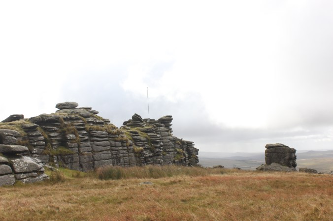
From the bottom of the path, I guessed it would take me about 15 minutes to get to the top. About half an hour later, when I was finally starting to feel I was almost there, I had to concede that looks, and distances, can be deceiving. But when I finally did get to the top, what I found was really quite remarkable. Several stone structures, most of which I hadn’t been able to see from the bottom, jutted out of the hill as if they had been pulled up from the ground with a giant pair of tweezers. Some formed perfect squares, others appeared to be stacked on top of each other precariously, as if one touch from my finger would send them toppling down the hill. The stones were darker than the surrounding earth, as if deliberately painted to look forbidding and dangerous, standing sentinel on the exposed hilltop.


But what were they for? How were they made? Did they occur here naturally, were they shaped from the hill by early settlers, or were they brought here, to serve a purpose? Were they ancient hill forts, build for defence? Ancient burial places? Or were they simply used to shelter those who (like me) sought a higher viewpoint? These were the questions I pondered as I stood amongst the stones, looking out over the moors and to several other hills, where I could see similar stone formations. Could it be that these remarkable structures occurred naturally on the hills, scored and shaped by the passage of time? Or were they perhaps a series of forts and settlements, marking the edge of an early kingdom? Perhaps we will never know – but then, the mystery, in a way, does add to the charm.

I stood up on the hill for some time, exploring and pondering, watching as the sun moved in and out from behind clouds so the light was continuously changing. I climbed over the stones and sometimes took shelter underneath at the moments when the sun was covered and the rain blew in. It was stark, and desolate – I could see a long way in every direction but nowhere could I see another human being – only a few sheep. Not until I was on my way back down again did I see some other walkers heading up. Unfortunately, it was on my way back down that the sideways rain began again, and the side of the hill was completely exposed. As I had nothing to take shelter behind, and wasn’t about to go down the hill backwards, I was completely soaked on one side by the time I reached the bottom. The battery on my camera was getting worryingly low, as well, but I wasn’t ready to give up just yet. From the car park there was a field out to the left and I could see a group of tourists in the distance, so I headed off in that general direction, thinking that they could only be there if there was something to look at.
I am pleased to say that it was here that I found what I had been looking for all along, and was most determined to find that day – the Merrivale Stone Rows. Two rows of upright stones, roughly a metre apart, stretching for about 100 metres along the valley, apparently to nowhere, with a larger closing stone at the end. About 2 metres to the right was another, smaller row, leading off in the same direction.

They really are quite incredible – but what on earth were they for? I walked along one and then back up the other, imagining myself in the place of a Bronze Age settler. Apart from the closing stone, and a circle in the middle which may have been a well of some kind, there was nothing at all unusual about them, apart from the fact that they exist. Surely they must have served some ceremonial purpose – at festivals, perhaps, or coming of age rites, funeral processions or perhaps as a connecting route between two rival settlements. It was wide enough for me to walk down comfortably, but it wouldn’t fit two people, and definitely not livestock, so it can’t have been a transport route. Who knows? We probably never will.
I spent some time wandering around the area, which was full of prehistoric surprises. Low stone walls which were probably used for keeping animals, wells, small hut-shaped foundations and great stone slabs that were probably tombs. There was even a perfectly preserved stone circle, which I stood in the centre of for a little while, wondering what rites and rituals might have been performed in that spot. I could see many stone markers dotted over the field and heading off into the distance, any markings they may have had long worn away by time. Were they ancient road signs? Sundials, perhaps, or border markers? It’s another mystery that will probably never be solved.
At this point I could see the tourist group heading back to the carpark so I made my way back and headed off before they could arrive and block the road. As my camera battery was now dead, and my feet still soaked, I popped back to the hotel for a cup of tea while I recharged and dried off. Then I set off for the afternoon. My first stop was in a small village nearby called Bellever, which has a very pretty forest walk and another clapper bridge. Unfortunately, this bridge was missing its middle stone, presumably long since washed away by the river, and the forest walks, although marked on a lovely map with different coloured dots and dashes, didn’t seem to have corresponding paths on the actual ground. I tried one, and ended up at a gate with a ‘private property’ sign on it, and another one which ended at a road with no signs to indicate where it went next. So I gave up on that and moved on.

I ended up taking a diversion here, which some might call going the long way round, or perhaps simply ‘going the wrong way’. Anyway I ended up taking much longer than I should have done, however I did enjoy a lovely drive through some charming looking villages, with equally charming names, like Lustleigh, Bovey Tracey and Widecombe In The Moor. I even passed a sign post pointing to somewhere called ‘Doddiscombsleigh’. Eventually I did get to where I was going, which was a small pub called the Sandy Park Inn on the outskirts of a village called Chagford, in the north of the national park. I wanted to stop by here because it was where I stayed on my previous trip to Dartmoor, when my grandmother was over for the Olympics. We had a lovely stay there, despite the fire alarm going off at five in the morning, and my nanna and myself stepping out of the room to be confronted by a middle-aged man, sopping wet and with just a towel around his waist, having just dashed out of the shower. Unfortunately, the hotel side of the pub is being renovated at the moment, so I couldn’t stay there, but I wanted to stop by all the same.
I’m pleased to say the bar area hadn’t changed at all, and neither has the setting – it’s on the corner of a cross road, where one of the main roads through the national park meets a narrow road that winds up towards farming areas and the local landmark, Castle Drogo. I have a very pleasant memory of coming back down that road from the castle, to the politest traffic jam I have ever been involved in – it reminded me of one of those wooden puzzles where you have to slide several pieces out of the way before you can get one piece in the right place. People were moving back and forth in turn with remarkable patience, many waves and ‘thank you’s, and a lot of squeezing against hedges. Every so often a car would edge past the other way, and we would all go through the manoeuvres again as we all moved one place forward and started the whole process again. I remember reflecting at that time that this sort of thing would never happen in a city – people would be honking, swearing, and trying to get through as quickly as possible, not necessarily waiting their turn.
I had a swift half at the bar and chatted to the lady behind the bar, Tina, who as it turned out had been working there at the time when I stayed previously. Although we didn’t remember seeing each other, she could at least tell me all the news and gossip since I had been there, and we had a very decent chat. When I got up to leave, however, I found that I couldn’t – because there was a traffic jam outside. This time I could easily see the source of the problem – a bit further up the main road, at a bend in the road, a tourist bus coming down the hill was wedged against a horse trailer going up. They had obviously tried to go around the bend at the same time and they were now very stuck. No traffic, from any of the other three roads, was going anywhere.
The locals seemed to find this all highly amusing and not at all irregular. The locals at the pub had all moved to the outside and were watching with drinks in hand as if they were at a local football match. Those in their cars had all switched their engines off, and some had even got out and were chatting to the pub goers while the bus shunted back and forth to no effect. Everyone was very relaxed – not a single car horn was honked.
Eventually a couple of people gave up and turned around, which meant that the rest of us could move along and I could get my car out. My last stop for the day was a place called Fingle Bridge, a little further up the windy road from the castle. It’s a charming stone bridge over a postcard-pretty English river, with a lovely café and outside eating area. This was another spot I wanted to revisit from my previous trip, and I had hoped to stop for a cream tea, but unfortunately due to my earlier diversion and the traffic jam I missed the café opening hours. I took a few photos of the bridge and headed home, via some more lovely views over the moors with the evening sun slanting down.


I made it back to the hotel in time for a swift half before dinner and to change my socks again. My friends from the previous night were all there and once again we chatted while we ate and shared stories, this time about the day we’d had. It was a satisfying end to an exciting and full day. I was tempted to book another night and do more exploring the next day, but I had places to go, starting with a stop in Plymouth for one specific thing… but that’s enough for one story, I think, so I’ll save it for the next one.
